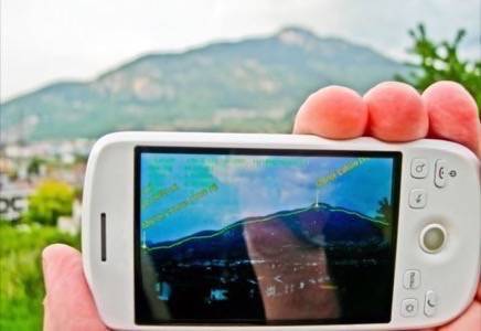
How many times have you been driving and wondered “What’s the name of that mountain?” or “Which river is this I’m crossing?” Maybe you consulted a paper map, or even your GPS, and were still uncertain. Well, that uncertainty may be a thing of the past with a new topographical augmented reality app called Marmota.

Up to now, when you thought of “augmented reality,” the picture in your mind was probably urban. After all, an architectural AR app or one that tells you all about a painting is of limited utility when you’re on the freeway or out on a hiking trail. That may be a matter of what’s available, not what’s useful.
Marmota, named for the ubiquitous Alpine rodent, is a project run by Claudio Andreatta, Michele Zanin and Paul Chippendale, all researchers at Fondazione Bruno Kessler‘s Technologies of Vision Research Unit. Given the FBK is located in the Dolomites of Northern Italy, a stone’s throw from the Alps, it makes sense it was developed there.
Zahn explains the system that powers Marmota.
“(It) integrates technologies and findings from different disciplines, spanning cartography to computer graphics, and sophisticated machine vision algorithms. Each pixel of the image is associated with information such as altitude, latitude, longitude and distance from the observer.”
How it maps, what it maps
A GPS reckoning taken by a user’s phone is sent to the Marmota server, which creates an AR layer that is sent back to be unpacked and overlaid. The over-layer is rich with topographical information, including feature names (mountains, peaks, ranges, rivers and other geological features), county names, altitude, latitude and longitude, hiking routes and roads.
The system operates against features up to 500 kilometers (just over 300 miles) away, and works from latitude 60 degrees north to 60 degrees south, or roughly from Calgary, Canada to Ushuaia, Argentina.
Marmota is an outgrowth of the same technology that has already produced the EagleEye photo explorer technology, “correlating geo-referenced landscape photos with synthetic three-dimensional models.”
The prototype currently being tested is Android-based and will be available for public user testing in the “immediate future.”
What tech do you use outside the city limits? Is Marmota something you think you’re likely to try when it becomes available? Or do you leave your tech behind in the rear-view mirror?