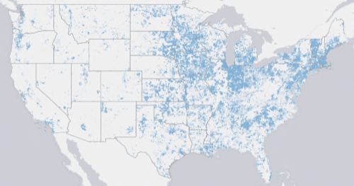
The National Telecommunications and Information Administration and the Federal Communications Commission have released a map of the broadband connections across the United States.

The most surprising thing in looking at the map? The reality that much of the country is not connected to broadband at all. But that was rather the point. The NTIA gives grants to projects in every state to increase the reach of broadband.

Areas of intense connection include the Eastern Seaboard, the Pacific Northwest, the Bay Area, the Chicago area and the Southland. The overwhelming majority of the Mountain West and Southwest, as well as inland Northwest and California are a broadband desert.
The map was built from 25 million documents that provided information on what kind of connections are available, who the providers are, where the connections are and what speed they operate at.
The site allows a user to analyze the data, browse the map or enter a specific location to see how connected it is. It also requests that users provide missing information, such as an unlisted broadband provider.
The APIs used to develop the map are all listed and developers are invited to use them.
The home page lists the top five locations that have been searched on.
- 38 w 45th st new york, ny 10036
- franklin mcpherson square
- 2 1st avenue, new york, ny
- 2017 mission street, san francisco, california
- ny
Other sources: PopSci


