Yesterday we discussed MIT’s project WikiCity, which monitors location data in cities via mobile sensors and creates visualizations from that. That project comes out of the SENSEable City lab at MIT and in our post we questioned whether there is any practical value in WikiCity currently or if it is simply “info porn”. In this post we look at a commercial company that is doing much of the same thing by using data mining and real time analytics and trying to make a business from that. The company is Sense Networks and its stated aim is to index the real world “using real-time and historical location data for predictive analytics across multiple industries.” Sense Networks was founded by top computer scientists from MIT and Columbia University.

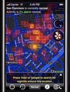
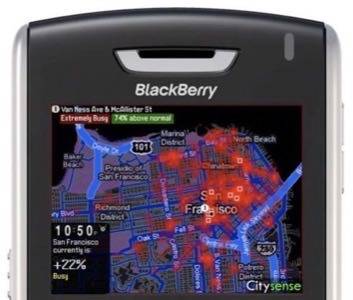
Sense Networks has a platform, called Macrosense, that “receives streaming location data in real-time, analyzes and processes the data in the context of billions of historical data points, and stores it in a way that can be easily queried to better understand aggregate human activity.” The company has so far built one consumer product on top of this platform: Citysense, an iPhone and Blackberry app that allows people in San Francisco to see the most happening nightlife in real time. Citysense currently accesses cell-phone and taxi GPS data from about four million GPS sensors, to see where the local hot spots are. It then links to Yelp and Google to show what venues are operating at popular locations. The product is currently only available in San Francisco, but a New York version is coming soon.

Citysense isn’t the only such app doing this, there are currently a lot of location-based social networking plays. They include “social compass” service Loopt (our review), Nokia-owned Plazes (our review), Pelago’s Whrrl, ULocate, and GyPSii. Probably our favorite right now is mobile social network app Brightkite, which at the end of last year we named our Most Promising startup for 2009. All of these apps offer something unique. For example Brightkite relies on actions from its user base to make it useful, whereas Citysense’s strength is its 4 million sensors and the aggregate data it derives and analyzes from those.
Sense Networks was the subject of a recent review by MIT’s Technology Review publication, which described how the next release of Citysense will show “not only where people are gathering in real time, but where people with similar behavioral patterns – students, tourists, or businesspeople, for instance – are congregating.” So we can see that Citysense is slowly evolving into a social networking tool, like Brightkite. In the next release Citysense will categorize people into “tribes” – so far 20 tribes have been identified, including “young and edgy,” “business traveler,” “weekend mole,” and “homebody.” In order to do this, Sense Networks not only uses GPS data, but company address data and demographic data about people from the U.S. Census Bureau.

The company’s monetization plans are predictably centered around location-based mobile advertising. This involves providing GPS data about city activity to advertisers, however the company insists that it will be aggregate data only – so user privacy is maintained. The user also can turn off the tracking and delete their existing data. An example of how advertising could work, via Technology Review, is data showing that “a particular demographic heads to bars downtown between 6 and 9 P.M. on weekdays. Advertisers could then tailor ads on a billboard screen to that specific crowd.”
We think this is a good example of how sensors and mobile data are being used to provide real value to consumers. Let us know other examples you’ve come across lately.


