Andrea Vaccari, from the SENSEable City lab at MIT, spoke at ETech recently about how cities are being transformed by mobile Web technologies. He described MIT’s project WikiCity, which monitors cell phone traces in Rome and creates visualizations from them. The goal is ultimately to make this data useful to actual people, in real time. The theory being that this will make cities run more efficiently. And we’re seeing proof of this to some degree already – for example electronic bus stop displays that tell you when the next bus is expected, based on GPS data. However, for the most part projects like WikiCity are still academic exercises. For the geeks amongst us, just another beautiful visualization of data to marvel at. When will these projects create meaningful change in cities?

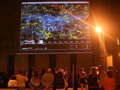
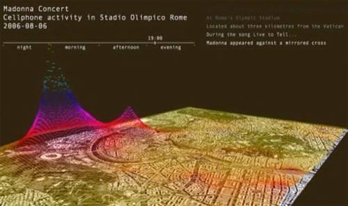
WikiCity is part of a wider trend in technology often referred to as the ‘internet of things’, in which real world objects are connected by a wireless network. WikiCity is described as an open source real-time system for a city. The city that Vaccari mentioned at ETech was Rome – others that are up and running are Copenhagen and Amsterdam. The goal of the WikiCity Rome project, which was a kind of sequel to the Real Time Rome project in 2006, is to answer this question: “Can you have a city that performs as a real time control system?” The components of this experiment are a city; sensors that accumulate data about the city’s state in real-time (commonly mobile phones and GPS data); computing “intelligence” to evaluate the data; and physical actuators to make any changes or adjustments to the city necessary.
Currently, the most common form of physical actuators are things like traffic lights and remotely updated street signage (we’ve already mentioned the GPS buses). However, MIT suggests that “a much more flexible actuator would be the city’s own inhabitants”. In other words, people can use and act on the data, which would then change the way the city operates.
As an example, according to MIT a person could “consult the [WikiCity] map to find the most crowded place in Rome to drink an aperitivo – and then identify the least congested route by which to reach it.” The theory is that people will then be helping to improve the efficiency of urban systems. Although, of course, it could become extremely inefficient if too many people choose the same crowded place in Rome to drink an aperitivo, and they all take the same “least congested route” to get there. One assumes that the system would update in real-time to offer alternatives, should that scenario occur. But the point is, this theory is untested. We have all this great data and pretty visualizations, but when will we be able to use this.
Jeremy Faludi of the WorldChanging blog wrote that WikiCity is merely “info-porn” at this point, because there hasn’t been follow through on the potential. We think that’s a fair assessment, but let us know what you think. Also we’d love to hear about other ‘real time city’ projects that you’re aware of – and are they helping real people yet?
Related RWW Posts: