PolicyMap is a new website that offers more than 4,000 points of data about any location in the United States, including demographics, real estate markets, crime, schools, housing affordability, employment type, energy consumption, and public investments. It’s powered by a new Application Programming Interface (API) from commercial mapping service PushPin.

That means that outside developers can access the same data that PolicyMap does and integrate it dynamically into other services on the web. Making this kind of information easily accessible could lead to some very interesting location-aware mashups.
Standard use of PolicyMap is free, but subscribers get access to proprietary data and projections, custom regions, more reports, and the ability to upload your own data.
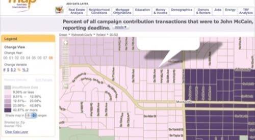
I’ll be moving next month, just six blocks away from where I live right now, but that part of the neighborhood is quite different. This is interesting data to look at. I did not know, for example, that a certain 10X10 block area I walk my dog through regularly is filled with people who have donated to the Presidential campaign of John McCain. No wonder I was the only one shocked when an openly gay man was elected Mayor of our city last night! I thought the whole city was filled with conservative lawn signs – but it’s just that little patch.
Continued below, just tech no politics.

As ProgrammableWeb’s John Musser pointed out in a post titled Demographics by API: Placestat and PolicyMap, the new REST API could really produce some magic if combined with last week’s launch of the Yahoo! Geo-location Database and API.
Policymap was developed in collaboration with a nonprofit called The Reinvestment Fund. Thanks to them and to Pushpin for making this information both publicly and programatically available.


