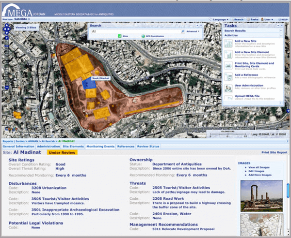
The Getty Conservation Institute has introduced the Middle Eastern Geodatabase for Antiquities – Jordan, a GIS-powered, map-focused site to “inventory, monitor, and manage Jordan’s vast number of archaeological sites.”

Working for four years, at the cost of $1 million, the Getty, with the cooperation of the Jordanian Department of Antiquities and the World Monuments Fund, has created a system for matching geographic information and historical research in a land whose history is vast and varied.
The project is two-fold. First, it will enable scholarly access to, ideally, every archaeological site in Jordan. Second, it will aid in the protection of ancient sites. Looting in nearby Iraq, and globally in general, is on the rise again.
MEGA lists over 10,000 sites of archaeological and historic importance, from the neolithic to Ottoman times. Information the integrity of these sites was formally listed only in a local Jordanian database, with no connection to the Internet.

The site was built with a number of realities in mind. It should be map-based, use free or low-cost software, be bi-lingual in Arabic and English, be easy-to-learn and customizable and allow the export of data that is fully compatible with other GIS tools such as Google Earth, Quantum GIS, and ESRI’s ArcView..
The project’s website will open next month to a group of authorized users. The intent is to open it to a wider and wider group as time goes on, as well as to spread the experience with the system to others who might be interested in implementing it in their country or area. Iraq, which was originally the target of an earlier version of the project but was given up in favor of Jordan due to instability, has indicated a desire to revisit the possibility of implementing the system in that country, according to Qais Hussein Rashid, Iraq’s Director of the State Board of Antiquities and Heritage.


