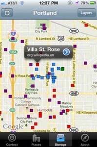
Geolocation data platform SimpleGeo released its own iOS app this morning to the app store (iTunes link). It clearly points to a future where all the data that’s available online about the real-world locations we find ourselves will be available in our hands with the click of a button.

Right now, the app lets you quickly view the boundaries of geographic areas you’re in (neighborhood, postal code, congressional district) and it lets you view other layers on top of your map like Wikipedia entries, Flickr photos and Project Noah wildlife sightings. Users with a SimpleGeo Storage account can log-in on the app and then view their own data layers placed on top of the map. That’s pretty awesome. Now if only we could share and view each others’ layers easily!
SimpleGeo seems to have built the app in large part in order to keep fresh in the kinds of app development activities their customers engage in. “Anything you see in the app can be done with a free copy of Xcode, SimpleGeo.framework, and a SimpleGeo account,” writes Ryan Gomba in the announcement. Gomba is a student intern at SimpleGeo and has been working on the app throughout the Summer.

I love this idea. There is almost nothing in the world that I want more from the Internet than to be able to use my phone to see current and historical news, demographic and other data about the physical places I find myself in. Nothing. Seeing this app really makes me want to take the time to go dig up some big geolocated datasets, throw them into SimpleGeo, log in on my phone to view them and then go explore the offline world. I would be happy and probably not come back to work for a while. I’ve got hopes like this for another startup, Geoloqi.
We’ll see where this all ends up going. This makes me feel like my dreams are coming closer and closer to coming true.


