Want to see who got part of the hundreds of billions of dollars in Recovery.gov funds near you? Now you can point your iPhone 3Gs or Android phone in any direction and see the closest recipients, thanks to the publication of the official data set onto the Layar Augmented Reality platform. Sunlight Labs published the marked-up information and the results are fascinating.

This may be the most accessible way to view this information yet. I must confess, I am surprised to see that an auto shop and a Bible college in my neighborhood received a lot more money than the technical college, eco-car company and Native American youth program down the road. Fire up Layar on your phone, search for “Sunlight” and you can see the effects of the funding program on your own neighborhood. This is the kind of thing that standardized data makes possible.
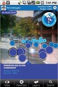
As Sunlight explains: “Layar is an application that overlays your view of the real world with waypoints representing your favorite coffee place, the movie theatre you’re trying to find, or in this case, where some of that $787 billion from the American Recovery and Reinvestment Act is going.”
Fortunately, the Recovery funding information was published by the Federal government in KML format – making it easy for 3rd parties like Sunlight to mash it up with services like Layar. I wish there was an option in the interface to Google the name of the recipient, not just look up its location. Right now there’s no information made immediately available beyond name, sum and address.
Sunlight was deeply critical of the initial release of data by the federal government this Summer. This is a great example of what kinds of things they and other groups can do when they get their hands on data.
So how does funding in your neighborhood look?


