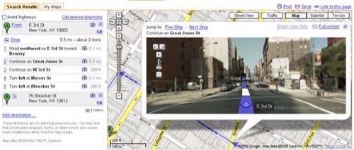
Since launching in May of last year Google’s Street View maps have expanded from the original 5 cities to 44 regions. Street View has largely been seen as a “fun” tool — Wired held a contest to find the best images captured from the service last spring, for example — and some have even found it rather creepy. Today, Google added Street View functionality to its directions application to create a very helpful service.

Probably the best use for Street View to date, has been as a means of identifying places you’ve never been. Though the street numbering is approximate, Street View can be used to check out what someone’s apartment building or office looks like before you visit — making it easier to find in the real world. But the process is tedious and involves manually clicking down a street until you find the portion you want.

By mashing up Street View and directions, Google has greatly simplified the process of using its street level panoramas to find specific locations. Any point-to-point directions covering an area supported by Street View will have a camera icon next to each step when Street View is on. Clicking on the icon will launch a Street View window, and the directions can be followed step by step within the street-level view.
That would have come in handy last weekend when directions I got from Google told me to take a “slight left” which was really more of a 90 degree turn. Had I been able to check out the step on Street View first there wouldn’t have been any surprises.


