Any way you slice them, borders can be a touchy subject. They’re disputed and fought over, with one country claiming one border and a neighboring country claiming another, putting cartographers in a tricky position – where to draw the line. Today, Google announced on its Lat Long blog that it had drawn those lines a little more clearly for more than 60 countries and regions, with the changes already live on Google Maps and coming shortly to Google Earth.

Some of the changes better follow geographic features, such as rivers or mountain ridges, while others attempt to portray geopolitical disputes, a feat that the company acknowledges can be a complex process and, already, is running into complaints about.
Tech blog Pluggd.in is already calling Google out for misrepresenting some geo-political borders, an issue for which it says Google PR already apologized before. The blog accuses Google of showing different maps to different countries, with Google Maps India showing a different border than Google Maps China.
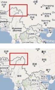
While one blog notes that Google simply shows these entire regions surrounded by dashed lines – to indicate the dispute over these borders – the country specific versions of Google Maps do not have the same image.
Charlie Hale, a geo-policy analyst for Google, explains many of the difficulties faced in creating a global map:
Making Google’s mapping tools as accurate as possible is a complex process, especially when a map’s accuracy has both quantitative and qualitative aspects. We receive spatial data of all kinds – imagery, boundaries, place names, etc. – from a variety of sources worldwide, and we review them carefully before integrating them into the best representation of a given location in Google Earth and Maps.
In the case of geopolitical features on our maps, the depiction of borders is something upon which local authorities, governments and internationally recognized bodies often disagree. Our goal is to provide the most legible and accurate maps we can given the information available in these oft-changing areas of geopolitical disagreement. Like most maps, ours include symbology that makes borders and other geopolitical features clearer to users.
Could this be a case of catch up, where Google has not updated its maps worldwide? Or is Google really catering to geopolitical concerns by showing different maps to different regions?
We’ve asked Google for comment, but have yet to receive an answer.