Using services like Google Maps and Google Earth has changed the way people interact with geography, compare notes with neighbors, and find their way from here to there.

Still, for all the beauty of Google’s directions, “street view,” and “search nearby,” the top-down views of our world have always been a bit fuzzy and squint-inducing. Until now. Thanks to Google hitching a ride on GeoEye-1, that’s all about to change. And today, we saw the first example of what’s to come.
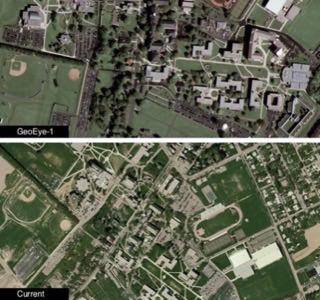
With access to the GeoEye-1 imagery, Google can now begin providing images for Google Maps and Google Earth that will boast a resolution of 50 cm. (That’s just shy of two feet for you non-metric types.)
Wired has posted the first photo from GeoEye, and it’s amazingly crisp.
Here’s a comparison between the new satellite image and the current resolution (GeoEye-1 image, top):

Looking for more resolution than that? You’re going to need to get security clearance. The US Federal Government restricts distribution of higher-resolution imagery, even though the image the satellite is capturing has a more detailed resolution (43 cm).
Currently, there is no specific date for when the imagery will be added to Google Maps and Google Earth.
One thing is for sure: When this new high-resolution imagery becomes available, Google Maps sightseeing will get a great deal more interesting.


