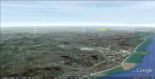
While we certainly don’t expect you’ll begin planning your days around the new feature, Google has added a new layer to Google Earth that makes it feel even more like you’re taking a live, real-time look at the earth from a satellite above – real-time weather.

Just added to the latest version of Google Earth, the feature offers a live view of the weather, from radar to raindrops.
Weather has been available in Google Earth since 2007, but now “the latest version projects images of rain and snow over the areas with those weather patterns as it’s actually happening”.
On a macro level, the weather layers offer a way to get a bird’s eye view of weather events like hurricanes. When you zoom in, Google takes it one step further and offers an animated view of the rain or snow for that area. The precipitation data currently only covers some areas in North America and Europe

The added layer is available in the latest version of Google Earth, which was released in early June with enhanced functionality for both free and pro users.


