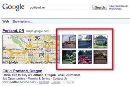
This morning, Google announced that it will now display images next to some localsearchresults. For the last two years, Google generally showed a map as the first item on the search results page whenever a user searched for a location, but now, a grid with six pictures will also appear next to this map as well. These images come right from the Panoramio photo layer in Google Maps, and clicking on it brings up Google Maps with the photo layer.


Great for Cities – But not for Sights
While this worked quite well for the examples Google gives in its blog post, a few of our other searches (‘Yosemite National Park‘ for example), did not bring up any photos. Any search for a city, however, always gave us related images from the photo layer in Google Maps. Searches for local restaurants and sites typically don’t bring up any images and searches for local sights already brought up search results from Google Images anyway, and from what we can see, nothing has changed there.
It’s nice to see, however, that Google now surfaces more images. It is also worth pointing out that yesterday, Google also announced that users can now easily filter Google Images by Creative Commons license, which, until now, was really the domain of Yahoo’s Flickr, which hosts the world’s largest repository of CC-licensed images.
Competing With Bing
Of course, we also can’t help but think that the fact that Google is facing renewed competition from Bing, which also does a nice job of mixing up images with local search results – though not quite as nicely as Google now does. Travel is one of the areas where Bing excels, and it is good to see that the competition in this market is driving all players to innovate and improve their services.


