There were two developments in the 3D mapping space today. First Microsoft finally launched the 3D version of New York City as part of an expansion of its Virtual Earth maps. Second, Massachusetts-based start up EveryScape launched a technology demo showcasing their own (sort of) 3D map service, which uses interactive, panoramic photographs mashed up with Google Maps.

Microsoft’s new 3D maps debuted today with nine new cities: New York (NY), Austin (TX), Cape Coral (FL), Cincinnati (OH), Indianapolis (IN), Northampton (UK), Ottawa (CAN), Savannah (GA), and Tampa (FL). The most notable, of course, being the long-awaited addition of New York City. Microsoft intends to add more cities throughout the summer.
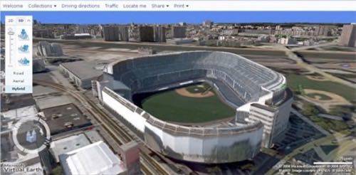
I hadn’t tried Microsoft’s 3D Virtual Earth maps until today, but was pleasantly surprised. Everyone was impressed when Microsoft debuted their close aerial “Bird’s Eye View” maps in December 2005, but because the 3D maps can be rotated and explored from any angle, while still maintaining nearly the same level of photo realism, they are infinitely more useful. They look a lot better than the 3D maps currently offered by Google, by virtue of their photo realistic textures (they’re low-res, and rather rudimentary, but still look relatively realistic).
Looking inside Yankee Stadium in Virtual Earth

It took me a few tries to get the plugin properly installed, and rendering was a bit slow on my 20mpbs connection (so I can imagine people on slower connections might experience even slower maps), but in general I was very impressed by the Virtual Earth maps.
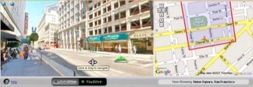
Today also saw the launch of a technology demo by EveryScape, a mapping company from Waltham, Massachusetts, which had been operating in stealth mode. The company uses 360 degree panoramic photos and Google Maps to create (mostly) street-level 3D tours of entire neighborhoods. Their demo shows off the technology in action in the Union Square neighborhood of San Francisco. It’s sort of a more sophisticated version of the old Amazon A9 Block View maps (which are no longer available).
EveryScape differs from the 3D options offered by Microsoft and Google in two main ways: it requires no additional browser plugins (just Flash), and it uses panoramic photos taken by humans. The latter means that users cannot change the axis of each scene, or even change the location from where the scene is viewed. But it also means the scenes are actually photo realistic, instead of almost photo realistic.

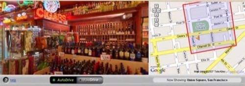
EveryScape’s technology also does something else that neither Google nor Microsoft offers: indoor panoramic scenes. EveryScape can theoretically take you inside businesses, restaurants, and a museums, allowing you to really virtually visit every part of a city or town.
Navigation around EveryScape panoramic images is easy. Click and drag to spin the scene in any direction (with a full 360 degree range of motion, both left and right as well as up and down), and click the green buttons to advance to the next scene. Clicking on the Google Map also brings you directly to the scene of that area. EveryScape also has the ability to embed marketing messages directly into their maps. In the technology demo, they’ve embedded messages on a few buildings pointing out business names and providing direct links to that business’ website.

Because each EveryScape scene is taken by a real person, filling out their inventory of maps, and completely mapping cities will take a lot of boots on the ground. The company hopes to recruit users to become “scape artists” and help fill our their catalog of scenes. I used to work as a photographer for a real estate company taking panoramic photos of the insides of houses. Creating a panoramic scene is pretty simple, but generally requires a specialized camera mount for the best results, as well as a wide angle lens. Scene stitching software is getting better, and will eventually eliminate the need for a lot of special equipment, but it can get complicated since every camera and lens is a bit different.
EveryScape, which has $10 million in VC funding led by Draper Fisher Jurvetson, intends to launch full cityscapes by the end of the year, starting with New York, San Francisco, Boston, and Seattle.


