Earlier this month I had the opportunity to attend the Augmented Reality Event in Santa Clara, California, and it was there that I discovered some amazing uses being developed using AR technology. I’ve already highlighted how it is being used to help doctors save lives, and more recently how it could be used to level the battlefield for soldiers in the middle east. Another example has an even loftier goal: helping to fight the climate and energy crises and save the planet.
Sean White, a postdoctoral research scientist at Columbia University and visiting scientist at the Smithsonian Institution, gave an inspiring talk at ARE 2010 about how he and others are experimenting with augmented reality and the environment. Climate change and other environmental challenges are “slow moving problems,” as White put it, so rich data visualization tools are needed to help scientists make sense of it all.
Identifying Plant Species
White has been working with botanists at the Smithsonian Institute to create mobile applications that can help scientists identify plant species in the field. Normally, identification requires looking at a leaf, and then flipping through pages of pictures to find a likely match. A skilled botanist can narrow down their search, but the process is still time consuming and difficult.
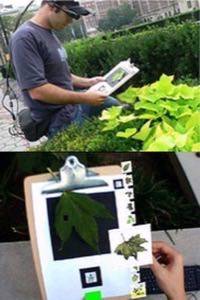
Using image recognition technology, White and the Smithsonian have created mobile apps that can help identify leaves from pictures. Simply snap a picture of the leaf, and the app narrows down the search to likely matches. What’s more, the scientists can make the process even easier by strapping on a head-mounted display (HMD) and comparing real leaves to virtual ones displayed in an augmented reality view.
Visualizing Carbon Dioxide Levels for Urban Planning
White also had his hand in helping to develop technology that collects and visualizes CO2 levels in urban areas. By rigging together a device that both detects CO2 levels and receives highly-accurate GPS and elevation data, White was able to create detailed heat maps of urban areas and their CO2 levels.

Taking that experiment a step further, the data was visualized in 3D space and superimposed onto an augmented reality view, providing a third dimension that takes data analysis beyond 2D maps. White says this kind of visualization helps determine causality when anomalies occur in the data.
He recalled seeing high levels in one specific area but wasn’t able to determine the cause by looking at the 3D maps. By using the augmented reality view of the data, it was discovered that the area with high CO2 levels was near a street corner where large trucks waited in line to make deliveries. This type of analysis of the data would not have been possible by simply looking at a map.
Finding Optimal Spots for Wind Turbines
The third example White shared focused on wind turbines, and on using AR data visualizations to help pick the most optimal wind locations. Using light detection and ranging (LiDAR) technology, scientists can point the devices up at the air from a spot on the ground and watch particulates float by to determine wind speeds and directions.

In the past, large towers were erected to detect this type of data, but they are expensive, limited in their range and take a long time to set up. Using LiDAR, which is cheaper and easier to use, scientists can cover larger areas and collect more data and reconstruct it into visualizations. They can then use augmented reality to see this data overlaid onto their real-world view to find ideal spots for wind towers.
AR is a Start
What else can AR do to help Mother Earth? An interesting implementation I would enjoy seeing would be to create 3D visualizations that help show the slow death march of the climate crisis. For instance, travellers visiting glaciers could hold up their devices and see what the landscape looked like from their perspective in years past – revealing the gradual retreat of glaciers from global warming.
So can augmented reality help save the planet? Not all by itself, no. But when used to help both scientists and everyday people better see the data in the world around them, it can certainly be a useful tool.