Everyone knows the first version of Apple’s iOS map application was a piece of work, but life-threatening?
Lots of people are upset with Apple for replacing Google’s all-but-bulletproof mapping app with its own, disastrous Maps application back in September. Locations are mislabeled, directions are absurd, towns are shown where no town has existed. It has been frustrating for many people, but few using iOS Maps have said it is really life threatening.
Until now.

Police in Victoria, Australia, have fielded several distress calls from motorists following Maps only to become lost in Murray Sunset National Park. The park is located in southeastern Australia where can temperatures can reach 114 degrees (46 degrees Celsius).
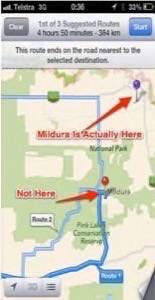
Motorists using Maps to get Mildura, Australia, located on the northeast border of the park. Their iPhones and iPads instead placed Mildura in the middle of Murray Sunset, miles from anything. Police say motorists insufficiently prepared to survive being lost in the sprawling park could find themselves in very real danger.
In a statement, the Victoria police department said travelers should rely on other maps until the problem is fixed. Department officials said they’ve contacted Apple with their concerns.
This is not the first time that a government has been upset with Maps. Irish officials were perplexed when the app moved Dublin Airport — a major facility — to a rural estate named “Airfield.” They called it “dangerously misleading.” That gaffe was fixed (but political hystrionics aside, it is extremely rare for pilots anywhere to use a smartphone for navigation).
Screen grab from Victoria police. Notations by the auhor.
Top photo courtesy Shutterstock.


