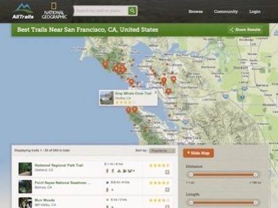
National Geographic Maps has partnered with AllTrails, an online network for outdoor enthusiasts, to launch a co-branded service at alltrails.com. The site aims to be a comprehensive destination for people planning hikes or other backcountry outings. Its 200,000 users can browse nearby or search for trails, post reviews and photos and share trails with friends. Users who have completed a trail are listed on its page.

Trail profiles give time and distance measurements, weather forecasts and routes overlaid on topographic maps. AllTrails initially used Google Maps data but found it to be too inaccurate for safe planning of wilderness trips. After Google began to charge for access to the Google Maps SDK, AllTrails began to explore other partnerships. Today’s announcement with National Geographic is the beginning of an integration that will move AllTrails away from Google.

After Google announced they would charge for developer access to Maps, AllTrails founder/CEO Russell Cook says that “a handful of projects were kicked off to improve the open source alternatives but there wasn’t nearly as much activity as I expected.”
After Google revealed the pricing in Q4 of 2011, Cook says “things kicked into high gear.” The pricing was “significantly higher than I think anyone anticipated,” Cook says. “Most publishers are lucky to consistently monetize their site traffic at $1 CPM, let alone be able to build profitable business models while paying Google $4 CPM for mapping.”
“Deep down I think the developer community knew that at some point the Google APIs they were using would stop being free,” Cook says, “but I don’t think they ever expected the price gouging. My personal opinion is that Google has every right to charge for the services they are providing but their recent actions have been very short sighted.”

Even before Google announced it would charge for access, AllTrails was reevaluating its mapping tools. “We found Google Maps to at times be wildly inaccurate,” Cook says, “which is something our audience can’t afford when out in the wilderness.” By licensing mapping content from National Geographic, AllTrails has begun to move away from Google.
National Geographic’s TOPO! allows AllTrails to overlay detailed topographic maps of terrain. Currently, AllTrails still uses Google Maps for its core services, but Cook looks forward to “some of the very exciting projects the Bing team will be releasing this year.”
AllTrails is available on the Web at alltrails.com. Its smartphone app is also available on the iTunes App Store and Android Market.


