Currently, the population of urban areas is increasing at a very high rate. Urbanization is rising all over the globe. People usually move from the countryside to more developed cities because of job and education opportunities. In developed economies, 79.2% of people live in cities. In the developing world, the amount is lower but is still more than half (UNCTAD).

Urban population growth has been fueled by new technologies that have enabled cities to build upward. The development of skyscrapers has allowed for greater population densities. In the future, we will see the continual expansion of today’s cities.
Urbanization has led to a new type of city called the megacity – this is a city with 10 million or more inhabitants. According to the United Nations forecast, there will be 43 megacities by the year 2030.
Jobs in manufacturing and IT and increased opportunities for education and entertainment attract people from rural areas and towns. Urban areas will continue to expand with the population. This further growth will create a number of challenges, including overcrowding, housing problems, traffic congestion, and reduced environmental quality.
Thus, it’s necessary to pay attention to building cities of the future. This means more comfortable and well-maintained areas designed for pedestrians and vehicles. Urban planning is an essential step in creating a well-developed city. It results in happier people living in this built-up environment. Planning includes safe and affordable housing, better public transportation, and public green spaces.
Pedestrian flows and parking problems
Pedestrian path design is important to make spaces near apartment buildings comfortable for people living there. In addition, city designers must consider pedestrian traffic and car movement. This can help to avoid traffic congestion when entering the apartment building property from the road.
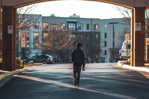
Image Credit: Unsplash; Thank you!
Pedestrian pathways
Simulation modeling allows you to test various scenarios without risk. It is possible by using pedestrian flows and analyzing them before implementing the project. Simulation enables experimentation on a real digital representation of a system.
In a pedestrian simulation model, you can define the area where pedestrians can move around. They will search for a faster way to their destination. It can be used for the design of pedestrian pathways around an apartment building.
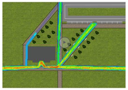
The simulation model of pedestrians’ routes
A lack of parking spaces near apartment buildings can be also solved by using simulation. In a model, you can test a few combinations of parking area dimensions with driveways and roads.
Furthermore, simulation software helps to avoid traffic congestion around an apartment building by modeling car movements. A simulation model gives the opportunity to predict the situation on the road. It considers the current traffic flow and the road network. Through car movement optimization, traffic jams at crossroads can be reduced.
Crowd management
Pedestrian flows need to be efficiently managed not only around the city but also in popular, crowded places. For example, visitors’ behavior at the Eiffel Tower in Paris was analyzed by using AnyLogic simulation software. The model simulated tourist arrivals and their behavior in open spaces.
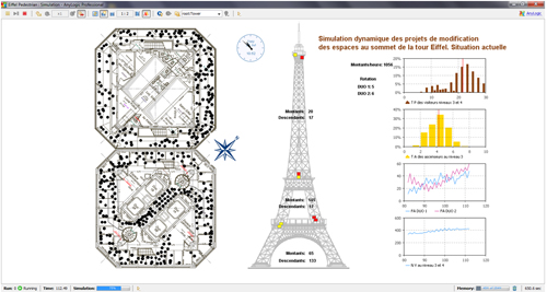
The simulation model of pedestrian flow at the Eiffel Tower
The simulation software estimated queues in front of elevators. At the same time, it considered elevator operation rules and capacity. The top floor had the biggest issues of waiting lines and crowd management. Experiments with a model were useful in optimizing the existing visitor itineraries.
Public transport: bus routing
Every day, millions of people move around between their workplaces and their homes. As a result, thousands of vehicles run on the streets. This leads to traffic jams and congestion.
Most of these vehicles run on fossil fuels. These fuels cause a huge amount of air pollution, degrading air quality. The number of people who own cars is growing every year because the public transport systems are still unreliable. That’s why it needs updating.
Cities are trying to make their streets friendlier for bikes and pedestrians. Vienna, Munich, and Copenhagen have closed entire streets to car traffic. Barcelona and Paris have dedicated more of their streets to bike traffic. Drivers in London and Stockholm must pay a fee for driving into the city. These measures make people more likely to walk, ride a bicycle, or use public transportation.
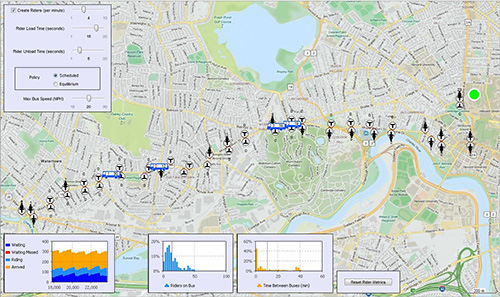
Bus bunching
Another problem in big cities is bus bunching. In the real world, traffic congestion, schedule gaps, mechanical failures, overcrowding, and uneven loads cause inconvenience and impact the rest of the route. Simulation modeling enabled the public transit agency to calculate several indicators such as irregularity measures, excess wait time, and passengers’ comfort levels.
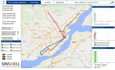
Bus bunching problem simulation
The simulation model allowed experimentation based on input data and the assessment of multiple ideas and combinations to solve this bus bunching. It helped public transport efficiently serve customers.
Transit vehicles scheduling
In public transport, bus bunching is when a group of two or more transit vehicles run in the same location at the same time. Thus, bus drivers need transit vehicle scheduling to be evenly spaced along the same route. To prevent public transit bus bunching, designers developed the simulation model with the following components: bus stops, buses, riders, and trips.
The solution called “equilibrium” showed the best results. This is a method used to devise a way to maintain distances between buses. Using the equilibrium policy, buses will no longer follow the route freely. They will continuously make adjustments, slowing down or stopping until sufficient space is available.
Bus transportation system simulation
When the “equilibrium” policy is used, the number of riders on each bus is more uniform. Moreover. the wait time is more predictable. This eliminates excessively long wait times and reduces overcrowding of buses. The implementation of a simple uber-like app for bus drivers could advise them when to wait based on network metrics, enforcing the “equilibrium” policy.
Municipal electric vehicles
By 2025, 45% of public buses in the EU should be low- or zero-emission. Simulation modeling was used to plan municipal electric vehicle (EV) fleet operations in Germany. It enabled the forecasting of large-scale EV fleet tasks and assessing their daily operation.
A user could choose vehicle types (diesel, BEV, FCEV), select the number of each type in a fleet, and set the number of charging stations in the depot and their maximum power.
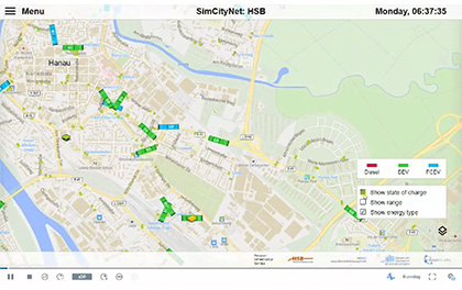
The electric bus operations model
Also, on the map view of the model, the user had the opportunity to see different types of buses moving on the streets, their states of charge, energy types, stops, and the charging station (the depot). The user could also select an option to consider the temperature effect on vehicle energy consumption.
With the help of the AnyLogic model, the simulation service provider gained insight into potential power needs for the charging infrastructure. They also calculated the number of required vehicles of each type.
Bicycle sharing
A developed bicycle transportation system is an important part of urban planning. It can help to reduce traffic congestion and environmental pollution. Bike-sharing systems are becoming more popular across the world.
In Mexico, modeling helped to estimate how many people would use the applied system in each macro-area. Also, it showed how they would behave while using a bike-sharing system.
The experiments with the model enabled engineers to analyze the number of different demand scenarios. They identified the busiest stations in the system and defined the number of bikes at each station.
The bicycle transportation system model
Railway passenger traffic
The efficiency of train terminal management influences the process of passengers’ control and experience. To optimize the utilization of the terminal in Paris, a simulation model was developed. This optimization could reduce the waiting time at the points of control for passengers.
The model considered a few elements. They were passenger flows classified by typology, the number of available posts of control as well as their flows, areas of waiting and control, and finally, a possible pre-orientation of the passengers. Using the simulation software helped deal with increased passenger traffic. The use of the terminal was optimized while enhancing the passengers’ experience.
Airport passenger flow
An airport provides mobility for its inhabitants. Frankfurt airport processes needed optimization to improve capacity planning and reduce waiting periods. It could increase customer satisfaction. Developers created an airport simulation model to develop an airport passenger flow management system.
The trajectory model and the social force model provided the required accuracy to forecast airport passenger flow. The terminal management of the airport has successfully been using the airport simulation model. As a result, it enabled managers to optimize passenger flow and avoid problems.
The role of simulation in building comfortable cities
Strong city planning will be essential in managing high energy consumption, poor air quality, and other difficulties as the world’s urban areas grow.
As we see, optimization technologies such as simulation modeling play a significant role in building modern and convenient cities. The simulation helps through the planning and improvement of pedestrian flows, parking, bus routing including EVs, bike sharing systems, as well as railway and airport passenger traffic.
The AnyLogic Pedestrian and Road Traffic Libraries enable users to plan, design, and simulate pedestrian and transportation flow dynamics in urban landscapes.
Since we have the data and know how to change today’s cities through urban planning, we must act now. This will allow us to overcome this set of issues and make urban environments sustainable.
Inner Image Credit: Provided by the Author; All Images by AnyLogic Simulation Software; Thank you!
Featured Image Credit: Photo by Ryutaro Tsukata; Pexels; Thank you!