Google Maps added public emergency alerts today for weather, earthquakes or other public safety concerns. Users can browse all active alerts at google.org/publicalerts, and relevant alerts will also appear on normal Google Maps searches depending on the query. Clicking through an alert on the map displays more info from the organization sending the alert.
Alerts from the US National Oceanic and Atmospheric Administration (NOAA), the National Weather Service and the US Geological Survey (USGS) are included in the service. In normal Google Maps searches, alerts are shown based on their severity, the user’s location and the search query.
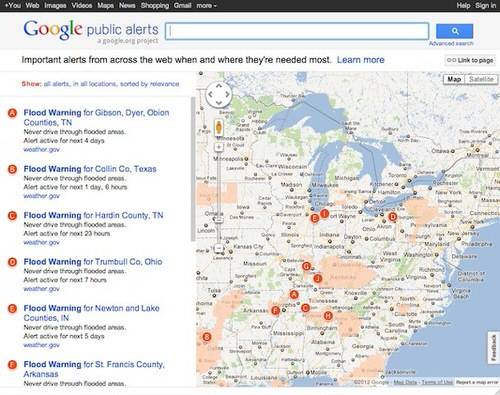
Last August, Google Maps added a weather layer that pulls in Weather.com readings and forecasts to help users plan. Now, if the weather is bad enough, Google Maps users will also get detailed warnings about its severity. Search queries will also highlight alerts; if your Maps search contains “flood,” relevant flood warnings will be displayed in your results.
This is the second announcement of new emergency uses for Google Maps this month. Google has partnered with the World Bank to make crowd-sourced Google Map Maker data available to first responders in disaster scenarios. In countries where the official Google Maps data does not have sufficient detail, local information submitted by volunteers through Google Map Maker can still be vital in emergencies. The World Bank can now connect Google to governments and NGOs responding to crises, so they can access these more detailed, unofficial maps.