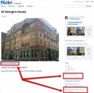
Flickr just announced support for OpenStreetMap, the wiki-like mapping service that allows users to create and edit maps. Starting today, photos that are tagged with an OpenStreetMap node ID will include a link to OpenStreetMap (OSM) right underneath the photo. OSM assigns a random number to objects on its maps and Flickr can now read this number and also extract additional data about places from the OSM database. In addition, Flickr also announced that it will now support venue ID tags for the increasingly popular Foursquare service.

Buzz Around OpenStreetMap
There has been quite some buzz around OpenStreetMap lately, especially in the mobile sphere. Given that developers often have to pay a lot to use maps from commercial vendors like NavTeq or Tele Atlas, OpenStreetMap, which is offering its maps for free, is becoming an increasingly interesting alternative, especially as the quality of the maps continues to improve.
Right now, for example, you can buy Roadee, a basic OSM turn-by-turn navigation app for the iPhone for a mere $1.99. Waze, which just released its own mapping and turn-by-turn naviation application, sadly doesn’t feed any of this data back into OSM, even though these two services could really benefit from each other’s expertise.
Making Flickr Smarter
As for Flickr’s integration of OSM, the company does a nice job at extracting interesting information from the OSM database when an image is tagged with an OSM ID. Thanks to this, Flickr can now understand if a building is a railway or subway station, for example, or if a certain place is a historic building, a farm, or a forest. Flickr only supports a small sub-set of all the tags that OSM currently supports, but as the Flickr team points out, OSM is still a moving target and it would be hard for Flickr to keep pace. After all, they still “have this little photo-sharing site to keep running.”


