Google Maps has just launched an “experimental” section called Labs where you can find the latest prototypes and test features to try out for use with the company’s online mapping service. As with other Google products, like Gmail for example, the Labs section lets users opt-in to features that – as Google describes it – “aren’t quite ready for primetime.” But some of the features in Gmail will never be mainstreamed into the email service itself – they’re simply fun extras which some people love but others would hate…or simply have no use for.

So will the new Google Maps Labs be the same? Filled mostly with fun but ultimately minor upgrades among a handful of gems? Or will it truly serve as the testing ground where the next major features planned for Google Maps make their debut? We checked it out this morning and found a couple of options worth enabling right now.
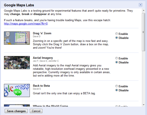
Discovered by Google Blogoscoped, Google Maps Labs launched with nine experimental features. You can access this new section by clicking on the green test tube icon which now appears at the top of Google Maps. In the pop-up window that appears, you can enable or disable the extra features. Currently, the line up includes:
- Drag ‘n’ Zoom: Click the Drag-and-Zoom button, then draw a box on the map to immediately zoom into that place.
- Aerial Imagery: Available for certain areas, aerial imagery “gives you rotatable, high-resolution overhead imagery presented in a new perspective.”
- Back to Beta: This will simply add a “Beta” icon to the Maps logo.
- Where in the World Game: Guess the name of the country from satellite imagery.
- Rotatable Maps: This puts north facing downwards, for instance.
- What’s Around Here?: This will trigger a search for anything (“*”), showing the top places for a given location.
- LatLng Tooltip: Shows the latitude/ longitude of where your cursor is positioned.

Some of the new options clearly fit more in the category of “just for fun” – like the one that adds the “beta” label back to the service’s logo or the “Where in the World” game which lets you guess where you are based on satellite imagery.
Our Favorite New Features
However, a few of the other features are more intriguing. For example, the “Aerial Imagery” feature sounds suspiciously like Bing Maps’ “Bird’s Eye view.” In Bing, Bird’s Eye view lets you see aerial imagery in an angled view. Using four different angles, the perspective is more useful for seeing detail than traditional aerial imagery which looks straight down on the rooftops. In fact, Bing’s unique Bird’s Eye view feature has been one of the service’s key selling points for some time. But now, it sounds as if Google plans to add the same – especially since the Labs description notes “currently imagery is only available in certain areas, but we’re adding more all the time.“
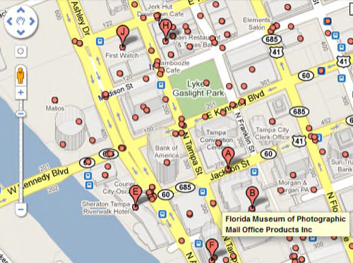
Another interesting option is the “What’s Around Here?” feature. Enabling this experiment adds a second search button next to the search box. When you have a map pulled up on your screen, all you have to do is click that button and thousands of round markers appear on the map denoting places of interest. This is a handy way to explore an area when you don’t necessarily have something in particular that you’re searching for. It’s easy to imagine how a future version of this feature could tap into other Google location-based services like the new Google Buzz or Google Latitude, for example, in order to add layers of social activity to the map, similar to Bing’s Twitter “mapplication.”

The two features described above registered as the stand-out options worth enabling right now, but we’ll definitely be watching the Labs section to see what other options show up later on. Do you have any feature requests you would like to see appear in Labs? If so, let us know in the comments.


