This week in our Read/WriteWeb Files feature we’re taking a look at personalization tools in development at Google. In April of this year Google added a personal touch to their Maps service with the addition of the MyMaps feature that lets anyone create a maps mashup. The feature, though four months old, is still tagged as “New” by Google.

Some bloggers thought that MyMaps was a response to enhanced personalization tools that Microsoft added this year to their Live Local service. But as ProgrammableWeb reports, Google’s mapping API has inspired by a large margin the most mashups of any API offered on the web. So, it is natural that Google would want to capitalize on the popularity of their maps mashups and offer simplified map mashing tools to the masses.
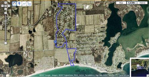
Google’s MyMaps is a very simple tool that let’s anyone mashup data with maps by adding placemarks (i.e., to mark where you went on vacation), to draw lines (i.e., to depict your biking route), or draw shapes (i.e., to mark off property lines). At its most simple, MyMaps can be used to do things like track and share your jogging routes and patterns or to share your vacation photos in context of the location where they were shot. The service can also be used, however, for less personal things like creating a guided tour of landmarks in a city, or by businesses to mark off franchise locations.
A not-so-often-used jogging route to the beach from the house I rented in college.
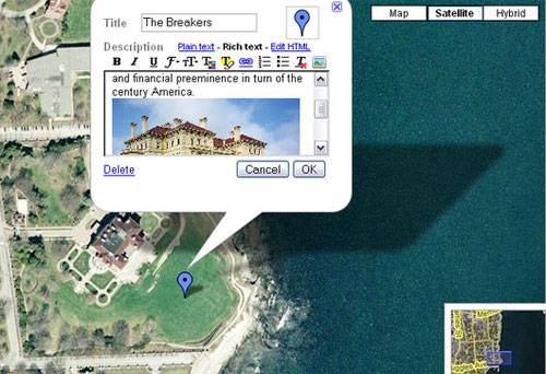
Placemarks, lines, and shapes include popup windows that can be edited with a title and description. Google includes a rich text editor that lets users edit fonts, sizes, and colors, add links, images, and YouTube videos, and even edit the HTML if they require further customization.
The drawing tools are very easy to use and about as intuitive as you can get. Everything you do can be edited or removed. If you make a mistake laying down a line, for example, you can move any point on the line by clicking on it and dragging it somewhere else on the map. You can extend the line by right clicking on the last point and choosing “Continue this line.”
In addition to marking locations on your map and drawing lines and shapes, you can also add third-party content to your creations. Google offers an extensive library of third party MyMaps content including weather, hotels, real estate listings, and gas prices. These Mapplets, as they are called, are created using the Google Maps API and reviewed by Google before being adding to the content directory.
You can add photos, like in this tour I made of mansions in Newport, RI.
Map mashups created with MyMaps can be saved privately and shared with friends and family via a unique URL, or saved publicly. When saved publicly MyMaps content may show up in Google Maps and Google Earth searches.
MyMaps is very easy to use, but it is simple almost to a fault. Though developers can use the Maps API to create more complicated mashups, there seems to be a gap between the API and the consumer-focused MyMaps offering. One of things I was disappointed that Google doesn’t offer, is the ability to measure shapes and lines on the map. It would be very useful to be able to draw out my jogging route on a map and have Google tell me how long it is, for example. Another oddly missing feature was the ability to merge shapes and lines. I accidentally drew out my jogging route using two lines. In order to make it one line, I had to delete the second and go back and extend the first.
Finally, it’s odd that Google doesn’t allow MyMaps creations to be embedded, which is a feature available to developers via the API. It seems that these simple mashups have less use if the only way you can share them is via a link. Being able to embed them into blogs and webpages would also help the service spread virally.


