Ah, the frustrations of trying to access a map on your phone when you’ve got limited Internet connection. Well now you needn’t worry with ForeverMap.
Google gets a lot of kudos (and, okay, triggers a fair amount of concern) about its mapping efforts with Google Maps and Google Street View. But even with innovations to the vehicles that Google is using to capture the data – tricycles, for example, not cars – it’s just not feasible to map everything.
There are alternatives to Google Maps, of course, and one of my favorites is OpenStreetMap, a collaborative map-making effort that allows people to correct and add information to maps. With a wiki-like process, OpenStreetMap, users can create and edit a map as a “living document,” often including much better local information.
I was introduced to the wonders of working on OpenStreetMap (thank you, Dave Lester) through Walking Papers which lets you print out a paper copy of a map so you can take it out, fill out the details, and then update the OSM website when you’re back in front of a computer. It’s perfect for times when you don’t have Internet access.
And now, there’s another way to access OpenStreetMap offline – paper and pencil not required. ForeverMap is a new app by Skobbler. While the European version of the app has been available for a while, Skobbler has just released a version containing North American data, with maps from the U.S. and Canada. While it doesn’t have every street corner mapped yet (of course, neither does Google Maps), it’s a pretty reliable option.
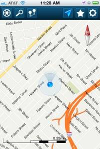
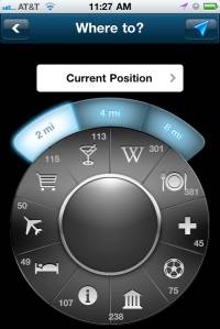
And the best part: it works offline. The app allows you to download a map of your location and lets you access all the data points there – points-of-interest, restaurant and shop info, route calculation data, and so on.
It’s worth pointing out that downloading a map does require WiFi access (not 3G – WiFi) in the first place, and depending on the region you’re in, the file size can be quite large. But once you’ve done so, you have a map in your pocket, or on your iPhone rather, that doesn’t require Internet connectivity.
The app is great for areas where there’s limited access to Internet and for users of iPod Touches and iPads who don’t have data plans.
(And while you’re out there in the great unknown, print out a copy of Walking Papers, make notes on what you see, and then add those details back to OSM when you get home.)