Although many of us have come to rely on Google Maps for navigation, the service is by no means the official arbiter of territory or borders. Nevertheless, twice within as many weeks, Google has found itself in the middle of geopolitical conflicts due to errors in its mapping service.

Last week, a Nicaraguan military commander using Google Maps, moved his troops into an area near the Costa Rica border that, come to find out, was actually – oops – in Costa Rica. The troops reportedly took down the Costa Rican flag and raised the Nicaraguan flag, which whether inadvertent or not, certainly made the incursion look a lot like a hostile act. The area was already disputed between the two countries, and according to the AP, a discussion with US State Department officials led Google to conclude that “there was indeed an error in the compilation of the source data, by up to 2.7 kilometers (1.7 miles).”
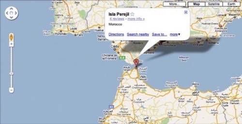
And today, Google admitted that there have also been errors in mapping a tiny disputed island 250 meters off the coast of North Africa. Spain calls the island Perejil. Morocco calls it Leila. And Google erred by first attributing the island to Morocco, then attributing it to Spain, when in fact neither country can officially lay claim to it.
Both countries do clam the islet, and conflict over it almost resulted in military confrontation in 2002. According to the U.S.-brokered deal ending the crisis, the island’s status was declared “under review.” The AP quotes Google Spain spokeswoman Marisa Toro as saying that the company learned in July about the error with assigning the island to Morocco, and under consultation from international bodies, are working to make the corrections on the maps.
Fortunately, in this case, neither Morocco nor Spain are preparing for further military conflict over the mistake. But as Google noted in a blog post on the subject this summer, it’s working to improve the quality of international borders on its maps, something that seems to be increasingly important as the service becomes one of the cornerstones for how we – military commanders and otherwise – move through the world.