
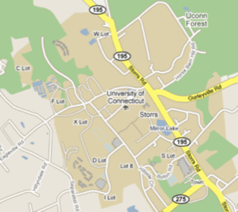
Google just announced a major update to Google Maps in the United States. The new version not only includes better maps based on data from government organizations like the Forest Service and the US Geological Survey, but it also allows users to easily report problems with a map. In addition, Google Maps now features better maps for parks and water bodies, as well as college campuses. Trails and paths now also appear on the maps and thanks to this, Google plans to add biking directions to its routing feature in the near future.

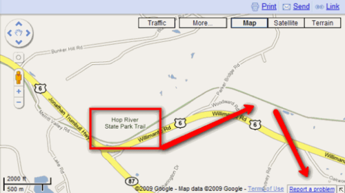
If you look at the new maps today, the most obvious changes are better data for park boundaries and the trails and paths that now appear prominently on the maps. In addition, if you see a mistake on a map (a bike trail that is marked as a road, for example), you can simply right-click on the road and the drop-down menu will now include the option to report a problem (there is also a link at the bottom of the map). Sadly, this feature doesn’t allow users to redraw maps themselves. Instead, you can only leave a short text comment. Other mapping projects like OpenStreetMap allow users to quickly redraw the lines themselves, though at the cost of increased complexity and a high learning curve. For now, Google promises to resolve each edit within a month.
All of this additional data also adds a new layer of clutter to the maps, though. For now, it is not possible to turn the information about trails and paths on or off, for example. If you are planning a route to drive with your car, you probably won’t care much about the bike trails. At the same time, if you are planning a bike trip, it would be nice if you could just highlight all the biking trails in a given area.
Focus on Better Maps Instead of More Satellite Images
The competition between online map providers has mostly been around adding new and higher-resolution satellite images lately. The Bing Maps July update, for example, came in at over 41TB of new satellite imagery and aerial photography. Now, it looks like Google is going back to pushing the envelope by focusing back on the straightforward mapping features that make up the core of every good mapping service.