Picture a technology that creates perfect 3D replicas used for archeological discovery, crime-scene investigation and virtual-reality entertainment—and I’m not talking about the Enterprise Holodeck. Far from science fiction, it already exists and it’s called lidar.
Even if you’ve never heard of lidar, you’ve heard about the things it can do. The technology has been harnessed for everything from the Makerbot 3D printer to Google’s potential self-driving car. Existing in some form since the ‘60s, lidar a light-based radar that senses and analyzes reflected light in order to make an exact 3D copy of any shape or environment.
Dr. Aaron Morris, a roboticist and entrepreneur on the cutting edge of 3D lidar research, said that in laypersons’ terms, think of lidar as a kind of virtual tape measurer, “except instead of rolling out a physical tape measure, it’s a beam of light, and a sensor measures how long it takes for it to bounce back to its source.” Multiply that bouncing laser beam by the thousands, make the source a rotating mirror, put the whole thing on a moving rover and you’ve got millions of data points mapping out a 360 degree view of a 3D space.
Though it sounds simple, the resulting breakthroughs have been nothing short of revolutionary. Here are seven ways that lidar is helping us live in the future.
Documentation
This spring, lidar-wielding archaeologists happened upon the stuff of legend. After scanning the Mosquitia rainforest in Honduras with laser-pulsing planes, they encountered unusual lumpy shapes that could be ruins. The most optimistic origins for the site is the Ciudad Blanca, or “the White City,” a mythical “lost city” whose existence has never been confirmed.
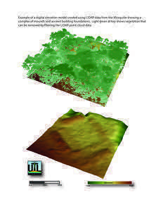
It’s an example of what Morris calls 3D lidar’s specialty: “making the invisible visible.” Lidar mapping revealed what decades of image-mapping couldn’t perceive through the dense foliage.
Lidar isn’t just for discovering new things, but for keeping track of what’s old. At the company he founded, Allpoint, (which has since been acquired by his current employer, Autodesk,) Morris has used lidar to scan wastewater management pipes and make sure what’s currently underground matches up with the original plans.
“Think about the impact that hitting an underground pipe or waterline has on residents in a neighborhood,” he said. “Lidar means we can be more efficient in how we do things. We can find out what’s underground before construction starts.”
Security
Have you ever wondered how stadiums, campuses and other spaces prepare for an unusually high-security event, like an in-person visit from the president? More and more frequently, the answer is 3D lidar.
The event space may contract a company like Autodesk to survey the area with 3D lidar. Then, once the space is mapped, it’s easier to analyze, placing entrances, exits, crowd control and snipers in advantageous positions around the 3D shape.
“Any time the President goes anywhere, it’s always documented with 3D modeling,” said Morris. “They get that place digitized to the millimeter in order to do all sorts of planning and section people off. Whenever there’s a big event, there’s a lot getting captured in 3D.”
Search And Rescue
Imagine you’re a firefighter trying to rescue people from a burning building. You’re being radioed to upstairs in order to reach survivors. But suddenly, the ceiling caves in and your path to the stairwell is blocked off. Those survivors might be out of luck unless the person on the radio has building blueprints to show you an alternate route.
Lidar scanning could ensure up-to-date 3D scans of all buildings. And since lidar data is processed by machines, it can be used to instruct robots to do the rescuing in areas too dangerous for human rescuers. In cases for determining potential human danger, a rover equipped with a lidar scanner can replace a human surveyor.
See also: Robots Ride To The Rescue In DARPA’s Virtual Robotics Challenge
In one case, Morris and his team assisted a concrete plant that experienced a cave in. Instead of sending people into the resulting crevice, Morris ordered a lidar scan. The resulting 3D map revealed that the plant was sitting on top of a natural underground cave. Lidar showed which parts of the plant were in danger and needed to be reinforced.
Criminal Activity
Of course, if a technology exists, there’s always a chance of it falling into the wrong hands.
In something of a perversion of security uses for lidar, criminals could use 3D scans of a building or event space in order to pinpoint its weak spots and infiltrate it. Since much of the 3D mapping of our world is being placed in the public domain alongside Google Maps and related technologies, it could be easy to access. It’s still “could,” because there has yet to be a documented crime that makes use of lidar.
More often, lidar is used to detect criminal activity rather than encourage it, right at the scene of the crime. Its millions of data points can create the most accurate possible scan of the crime scene and all the objects within it. Also, since lidar’s lasers provide their own light, it can detect up clues that a regular camera might miss.
Augmented Reality
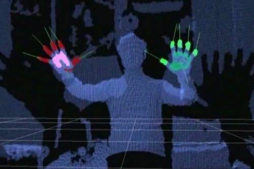
If you’re familiar with the Kinect, you’re familiar with lidar in the context of entertainment. The system scans and measures invisible infrared light in order to recognize human bodies in front of it. Though the Kinect has been lukewarm with players, it’s been a hit with robotics experts looking for a lightweight imaging device to hook up to robots.
Armed with Kinect imaging, robot butlers have become more of a reality than ever before. By wiring a Kinect to a humanoid robot, researchers at Cornell have designed robots that can not only detect human movement, but react to that movement’s most likely result. For example, a Kinect-assisted robot that detects a human making cereal will wait for the human to finish, use lidar to identify the objects used in the cereal making process, and replace the milk jug in the refrigerator.
Replication
“One of the guys I work with had a buddy capture images of a statue outside the baseball stadium and used lidar software to turn those pictures into 3D,” Morris recalls. “Then he used a Makerbot to cut it out and turn it into a Jell-O mold.”
While most commercial 3D printing examples are equally silly, the technology has the ability to make rare items more accessible. For example, Kenyan paleontologist Louise Leakey worked with Autodesk in order to digitize her personal collection of African fossils. Though they’re virtual, not physical, prints of the fossils, they’re highly accurate copies that can now be downloaded by any university in the world, without risking the fragility of the original objects.
Autonomous Driving
Perhaps most famously, lidar has made driverless cars possible. Much in the way that dolphins use echolocation to navigate their surroundings, driverless cars use lidar sensors in order to retrieve and analyze data about their environments in real time.
Since today’s driverless cars rely on GPS navigation, said Morris, they’re less effective in congested or high-traffic areas. Lidar data will help to make them far more accurate.
In Morris’s current work as the product manager of reality capture at Autodesk, he works with Google to make commercial driverless cars a reality, much of his process has been using lidar scanners to survey and 3D map America’s road infrastructure. Those maps will then be installed in driverless cars ahead of time so they can make better driving decisions.
“There’s never been a time before when we could practically capture reality,” he said. “I can train a robot without physically putting it in the environment because I’ve got such a good representation of what the world really is.”
Lidar image of a Chicago mass transit station, courtesy of HTNB.