For smartphone owners, asking people on the street for directions is quickly becoming a thing of the past. Why bother trying to remember a series of turns and landmarks when your phone can do that and more? Who needs confusing descriptions when you have satellite and Street View imagery? Android users certainly don’t.

Google has added “Walking Navigation”, a marriage of walking directions, turn-by-turn GPS navigation and satellite imagery, to the newest version of Google Maps for Android.
The latest addition comes as a part of Google Maps for mobile 4.5 for Android. It takes walking directions, which takes advantage of pedestrian pathways, overpasses and other such things, and pairs them with turn-by-turn GPS directions and satellite imagery.
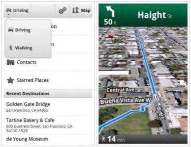
Simply enter the address of where you’re trying to go, chose the “Walking” option from the navigation icon and the app will guide you, following along and vibrating when you reach the next turn. The map even rotates as you turn the phone, orienting the map to the direction you’re facing. As Google engineers Andrey Ulanov and Kevin Law note in their blog post, you can “use it like a virtual compass with satellite imagery to look ahead or help pick out landmarks along the way.”
If the satellite view doesn’t offer enough in the way of contextual clues, the new and improved Street View navigation for Google Maps on Android should help. The feature brings street view straight to your phone and adds “smart navigation”, wherein you can simply drag the “Pegman” around to move your vantage point. Take a look:
We often joke with friends about how the smartphone is like the Hitchhiker’s Guide to the Galaxy, but it’s features like this that make that notion more and more a reality. It wasn’t long ago that GPS navigation in a car seemed like a modern day luxury, and now we have access to turn-by-turn directions and imagery in our pockets. The integration with satellite imagery is just a step away from Street View integration and we can’t imagine that an augmented reality addition is far off. While we often feel silly holding our phones up to the horizon to look for the nearest pizza joint, having this data on-screen as we navigate about our lives may prove even more handy.
What do you think – what’s next for mobile personal navigation? That is, aside from getting similar functionality for the iPhone?